 Get Data Now
 from Riverscapes Warehouse About
RC Data Warehouse RC Open Source
Tools on Github
 RC-Compliant
 Tools
Welcome to the Riverscapes Consortium! The Riverscapes Consortium is an international collaboration of people concerned with improving and sustaining riverscape health. Our vision is for a world full of vibrant, healthy riverscapes supporting coexisting, thriving ecosystems and human societies. A hallmark of these healthy riverscapes and our adaptation to the climate crisis will be their resilience to the increasing severity of floods, droughts, fires and species invasions.
Motivating Problem - Urgent Threats to Our Riverscapes
The world is utterly dependent on freshwater resources and riverscapes. Collectively, the world’s riverscapes have alarmingly poor health and are facing increasing threats to river biodiversity and human water security (Vörösmarty et al. 2010).
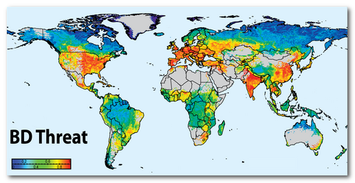
Global threats to River Biodiversity from Vörösmarty et al. (2010) and Rivers in Crisis (riverthreat.net).
The health of riverscapes can be improved and they can become more resilient to threats like increasing severity of floods, droughts, fires, exotic invasions, pollution and land use changes (Wheaton et al. 2019). However, it requires thinking more broadly and strategically, and working smarter with limited resources. Neither the scientific riverscapes community nor the management community are working smart enough or fast enough to tackle these challenges.
Some of the challenges are societal and political, but some of our scientific knowledge and capacity gaps are simply limited by antiquated ways of doing our science and a lack of standardization. Riverscape science advances have been massively limited by a lack of leveraging and integration of past contributions, existing data and models (i.e. failure to make our science FAIR). Technological solutions exist today to tackle these knowledge gaps and capacity limitations, and simply require strategic thinking and investment. Given how humankinds survival on this planet is so intimately tied to healthy riverscapes and clean water, we owe it to ourselves and future generations to make those investments now.
The Emergence of a Riverscapes Consortium
![]() Together with many talented and creative collaborators, we have built an international consortium of researchers and software developers who build tools and pioneer solutions to better understand, simulate & manage our riverscapes . We call ourselves The Riverscapes Consortium (RC). The consortium is not defined by any individual or single organization, but is rather a genuine collaboration of scientists and practitioners whose curiosity and concern about riverscapes and their ecosystems has brought them together. We believe a diversity of perspectives and approaches are necessary to tackle the biggest challenges and long-standing questions we face in understanding and better managing riverscapes.
Together with many talented and creative collaborators, we have built an international consortium of researchers and software developers who build tools and pioneer solutions to better understand, simulate & manage our riverscapes . We call ourselves The Riverscapes Consortium (RC). The consortium is not defined by any individual or single organization, but is rather a genuine collaboration of scientists and practitioners whose curiosity and concern about riverscapes and their ecosystems has brought them together. We believe a diversity of perspectives and approaches are necessary to tackle the biggest challenges and long-standing questions we face in understanding and better managing riverscapes.
What we do
The RC tackles these challenges buy supporting a stronger, more collaborative riverscapes community through four primary outlets of science, tools, data dissemination, and management applications. More specifically, we:
- Promote conducting and publishing of SCIENCE relevant to understanding riverscapes that is Findable, Accessible, peer-reviewed and rigorous.
- Develop and facilitate sharing of innovative TOOLS that are Findable, Accessible, and ideally Interoperable and Re-useable.
- Host and contribute to DATA Warehouses for sharing and discovery of riverscapes data, which are Findable, Accessible, and ideally Interoperable and Re-useable.
- Support a community of practice that leverages the above science, tools and data to pragmatically, tackle Management and Restoration solutions that scale to the scope of the problems of degradation and threats facing riverscapes.
Note that the F-A-I-R, correspond to the findable, accessible, interoperable and re-useable Principles (Wilkinson et al. 2016), which the RC strives to follow and to help facilitate making it easier for the riverscapes community to follow.
Get Data Now from Riverscapes Warehouse About
RC Data Warehouse RC Open Source
Tools on Github
RC-Compliant Tools
 Low-Tech Process-Based Restoration of Riverscapes Resources
Our consortium has been prolific in developing and vetting the science and theoretical underpinnings essential to understanding and explaining how riverscapes work and are organized across a range of nested hierarchical spatial scales. We have also committed to building open-source algorithms tools to make it easier for researchers, professionals, practitioners and students to apply those concepts to studying or managing their own riverscapes.
References
- Vörösmarty CJ et al. 2010. Global threats to human water security and river biodiversity. Nature 467 : 555–561. DOI: 10.1038/nature09440
- Wilkinson MD et al. 2016. The FAIR Guiding Principles for scientific data management and stewardship. Scientific Data 3 : 160018. DOI: 10.1038/sdata.2016.18
- Wheaton J.M., Bennett S.N., Bouwes, N., Maestas J.D. and Shahverdian S.M. (Editors). 2019. Low-Tech Process-Based Restoration of Riverscapes: Design Manual. Version 1.0. Utah State University Restoration Consortium. Logan, UT. 286 pp. DOI: 10.13140/RG.2.2.19590.63049/2.